| Table of Contents |
|---|
| Warning | ||
|---|---|---|
| ||
Starting June 2018 Google has updated their licensing guidelines for the Google Maps API. Please see this article for more information: Google Maps API Key |
Overview
Join Paul McClendon, an Opmantek Support Engineer, as he demonstrates how to create a geographical map in opCharts.
| Widget Connector | ||||||
|---|---|---|---|---|---|---|
|
The Geographical Maps style Map allows the user to create live geographical maps based on the Google Maps API. A menu listing of all available Maps can be accessed by selecting Views -> Maps from the opCharts menu bar.
Creating a New Geographical Map
1. A Geographical Map must be created before it can be used or added to a Dashboard. To create a new Map, Click the "+" icon from the Maps screen (Views -> Maps).

2. Next, select Geographical Map from the Map Type drop-down located in the top-left corner.
...
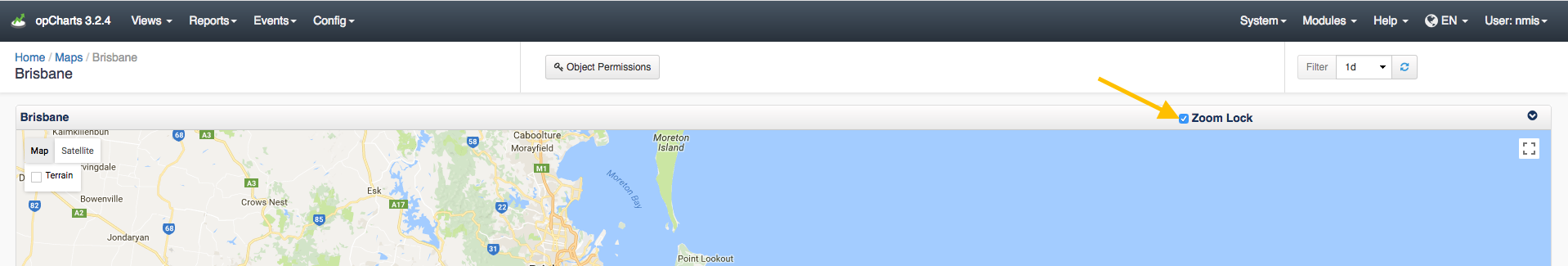
As of opCharts version 3.2.2 you can Zoom Lock the maps preventing them from zooming in and out when you scroll your mouse wheel. This option can be toggled on or off by the check box as shown in the screenshot below:
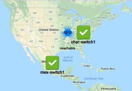
Geographical Maps clustering
As of opCharts version 3.2.6 Geographical maps will cluster items on the map that are too close together. You can get more information on the devices in the Cluster by clicking on the 12/12 icon as displayed in the image below. In this example, the Cluster Icon is indicating that there are 12 out of 12 reachable devices.
To disable this feature you can set opcharts_maps_geographical_clustering to 0 in /usr/local/omk/conf/opCommon.nmis